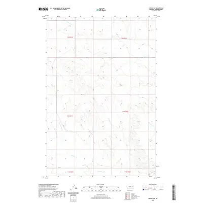
2020 Map of Lindsay SW
USGS Topo · Published 2020About this map
Bad Route Creek and its tributary, the East Fork Bad Route Creek, dominate the southern drainage of this eastern Montana landscape. The area is defined by a series of low-lying creek beds that cut through the undulating plains, including Clear Creek and Cracker Box Creek to the north and east. This 2020 map documents a sparsely populated rural region where movement is dictated by a handful of section-line roads such as Rd 217 and Rd 238. The Public Land Survey System grid provides the primary structure for the territory, illustrating the expansive ranching or agricultural tracts that characterize Dawson County. The convergence of these drainage systems toward the south suggests a landscape heavily shaped by seasonal water flow and the erosion of the high prairie.
Find a feature on this map
16 named features on this map. Tap any name to fly to it.
Don’t see what you’re looking for? This feature index may not catch every label — zoom into the map to look around manually.
Map Details
Editions of this 2020 Lindsay SW Map
This is the sole edition of this map. No revisions or reprints were ever made.
Other maps of this area

1953 · Miles City
USGS Topo · 1:250,000

1954 · Glendive
USGS Topo · 1:250,000

1957 · Miles City
USGS Topo · 1:250,000

1957 · Glendive
USGS Topo · 1:250,000

1958 · Miles City
USGS Topo · 1:250,000

1958 · Glendive
USGS Topo · 1:250,000
1967 · Fallon NE
USGS Topo · 1:24,000

1972 · Hendrickson Coulee
USGS Topo · 1:24,000

1972 · Diamond G Creek
USGS Topo · 1:24,000

1980 · Terry
USGS Topo · 1:100,000