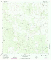
1963 Map of Linn NW
USGS Topo · Published 1984About this map
Deep South Texas ranching and petroleum development define this mid-century landscape in Hidalgo County. The infrastructure of the Beaurline Gas Field and Los Indios Gas Field is mapped alongside an extensive network of named windmills and wells, which were vital for maintaining livestock in the semi-arid pastures. Major cattle operations like the Santa Fe Ranch and Los Indios Ranch dominate the topography, connected by the Southern Pacific railroad and a grid of access roads. The presence of specialized features such as Charco Largo Well and Palomas Well indicates the reliance on artesian water sources within the Tres Lagunas Pasture and San Juan Pasture. This survey captures the region during a period of transition, where traditional Spanish-named land grants and ranches like El Rastrillo Windmill integrated with modern energy extraction and utility corridors.
Find a feature on this map
35 named features on this map. Tap any name to fly to it.
Don’t see what you’re looking for? This feature index may not catch every label — zoom into the map to look around manually.
Map Details
Editions of this 1963 Linn NW Map
3 editions found
Other maps of this area

1939 · Linn
USGS Topo · 1:62,500

1939 · La Reforma
USGS Topo · 1:62,500

1939 · Encantada
USGS Topo · 1:62,500

1949 · Mc Allen
USGS Topo · 1:250,000

1954 · McAllen
USGS Topo · 1:250,000

1957 · Mc Allen
USGS Topo · 1:250,000

1962 · McAllen
USGS Topo · 1:250,000
1963 · Callo Padrones
USGS Topo · 1:24,000

1963 · Linn NW
USGS Topo · 1:24,000
1963 · Linn Siding
USGS Topo · 1:24,000