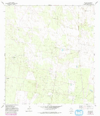
1963 Map of Linn NW
USGS Topo · Published 1993About this map
The ranching and energy landscape of Hidalgo County is clearly defined on this topographic survey, which highlights the transition between traditional grazing lands and the emerging petroleum industry. Large tracts such as Tres Lagunas Pasture, San Juan Pasture, and Santa Fe Pasture dominate the terrain, illustrating the historical scale of South Texas ranching operations. The infrastructure of these holdings is marked by numerous family-named landmarks and water sources like the Agua Dulce Windmill, Devisadores Windmill, and Charco Largo Well (Flowing).
Find a feature on this map
34 named features on this map. Tap any name to fly to it.
Don’t see what you’re looking for? This feature index may not catch every label — zoom into the map to look around manually.
Map Details
Editions of this 1963 Linn NW Map
3 editions found
Other maps of this area

1939 · Linn
USGS Topo · 1:62,500

1939 · La Reforma
USGS Topo · 1:62,500

1939 · Encantada
USGS Topo · 1:62,500

1949 · Mc Allen
USGS Topo · 1:250,000

1954 · McAllen
USGS Topo · 1:250,000

1957 · Mc Allen
USGS Topo · 1:250,000

1962 · McAllen
USGS Topo · 1:250,000
1963 · Callo Padrones
USGS Topo · 1:24,000

1963 · Linn NW
USGS Topo · 1:24,000
1963 · Linn Siding
USGS Topo · 1:24,000