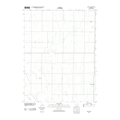
2009 Map of Linn SW
USGS Topo · Published 2009About this map
Garfield Center anchors this portion of Clay County, showing the persistent rural structure of the Kansas prairie in the early twenty-first century. The landscape is defined by a rigorous section-line grid of local routes like Jayhawk Rd and Kiowa Rd, which navigate the subtle drainages of Spring Creek, Peats Creek, and Dry Creek. For those tracing local heritage, the map identifies two significant burial sites: Peats Creek Cemetery in the northeast and Sherman Cemetery further south, positioned along the banks of Peats Creek. The arrangement of these cemeteries and the small settlement at Garfield Center reflects the historical distribution of farming communities that once densely populated this region, providing a clear record of land use and civil organization before further consolidation of modern agriculture changed the face of the Great Plains.
Find a feature on this map
16 named features on this map. Tap any name to fly to it.
Don’t see what you’re looking for? This feature index may not catch every label — zoom into the map to look around manually.
Map Details
Editions of this 2009 Linn SW Map
This is the sole edition of this map. No revisions or reprints were ever made.
Other maps of this area

1891 · Clay Center
USGS Topo · 1:125,000

1893 · Washington
USGS Topo · 1:125,000

1955 · Manhattan
USGS Topo · 1:250,000

1956 · Manhattan
USGS Topo · 1:250,000

1957 · Manhattan
USGS Topo · 1:250,000

1964 · Clay Center NW
USGS Topo · 1:24,000
1964 · Clay Center NE
USGS Topo · 1:24,000

1964 · Miltonvale NE
USGS Topo · 1:24,000

1965 · Clifton
USGS Topo · 1:24,000

1965 · Brantford
USGS Topo · 1:24,000