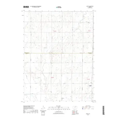
2018 Map of Linn SW
USGS Topo · Published 2018About this map
The Republican River sweeps through the southwest corner of this landscape, anchoring a rural territory where Clay and Washington counties meet. Centered around Garfield Center, the area is defined by a grid of section roads like Parallel Rd and Hackberry Rd that navigate the rolling drainage basins of Peats Cr and Spring Cr. For genealogists and local historians, the sheet is particularly valuable for its documentation of early community landmarks, including the Norwegian Lutheran Cem, Sherman Cem, and Peats Creek Cem. These small burial grounds, often located at intersections or along creek bluffs, reflect the late 19th-century settlement patterns of the Kansas plains. The terrain transitions from the river valley in the south to the higher prairie uplands in the north, where Dry Cr and its eastern branch begin their descent through the hills.
Find a feature on this map
38 named features on this map. Tap any name to fly to it.
Don’t see what you’re looking for? This feature index may not catch every label — zoom into the map to look around manually.
Map Details
Editions of this 2018 Linn SW Map
This is the sole edition of this map. No revisions or reprints were ever made.
Other maps of this area

1891 · Clay Center
USGS Topo · 1:125,000

1893 · Washington
USGS Topo · 1:125,000

1955 · Manhattan
USGS Topo · 1:250,000

1956 · Manhattan
USGS Topo · 1:250,000

1957 · Manhattan
USGS Topo · 1:250,000

1964 · Clay Center NW
USGS Topo · 1:24,000
1964 · Clay Center NE
USGS Topo · 1:24,000

1964 · Miltonvale NE
USGS Topo · 1:24,000

1965 · Clifton
USGS Topo · 1:24,000

1965 · Brantford
USGS Topo · 1:24,000