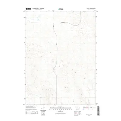
2014 Map of Linscott SW
USGS Topo · Published 2014About this map
Sandhills terrain dominates this part of Custer County, where the landscape is defined by the undulating topography of the Nebraska interior. Human activity is sparse, marked primarily by the transition from Mills Valley Rd in the south toward the northern reaches of the quadrangle. A significant corridor is formed by Dunning Rd, which cuts a north-south path through the distinctive dune formations. The inclusion of Arnold Dunning Oil suggests the integration of local resource infrastructure within this rural expanse, providing a specific point of interest for those researching the land-use patterns and infrastructure of the early 21st-century plains.
Find a feature on this map
3 named features on this map. Tap any name to fly to it.
Don’t see what you’re looking for? This feature index may not catch every label — zoom into the map to look around manually.
Map Details
Editions of this 2014 Linscott SW Map
This is the sole edition of this map. No revisions or reprints were ever made.
Other maps of this area

1948 · Linscott
USGS Topo · 1:62,500

1950 · Linscott
USGS Topo · 1:62,500

1951 · Hoagland
USGS Topo · 1:62,500

1954 · North Platte
USGS Topo · 1:250,000

1956 · North Platte
USGS Topo · 1:250,000

1957 · North Platte
USGS Topo · 1:250,000

1967 · North Platte
USGS Topo · 1:250,000
1972 · Davenport Table
USGS Topo · 1:24,000

1972 · Logan
USGS Topo · 1:24,000

1972 · Arnold
USGS Topo · 1:24,000