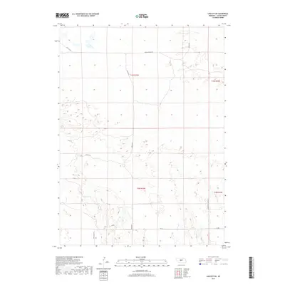
2017 Map of Linscott SW
USGS Topo · Published 2017About this map
The rolling sandhills of Custer County dominate this landscape, defined by deep incisions like Upper Powell Canyon in the southeastern corner. This area of Nebraska is characterized by a sparse network of county roads that follow the natural contours of the valley floors and ridges, serving isolated ranchsteads and grazing lands. Routes such as Dunning Rd and Mills Valley Rd provide the primary transit through this terrain, while Arnold Dunning Dr crosses the northern sections. The map reveals the systematic organization of the Public Land Survey System, with boundaries such as t19n r25w clearly delineated across the open prairie. This 2017 survey reflects the enduring cattle-ranching character of the region, where infrastructure remains minimal and tied closely to the land's topography.
Find a feature on this map
11 named features on this map. Tap any name to fly to it.
Don’t see what you’re looking for? This feature index may not catch every label — zoom into the map to look around manually.
Map Details
Editions of this 2017 Linscott SW Map
This is the sole edition of this map. No revisions or reprints were ever made.
Other maps of this area

1948 · Linscott
USGS Topo · 1:62,500

1950 · Linscott
USGS Topo · 1:62,500

1951 · Hoagland
USGS Topo · 1:62,500

1954 · North Platte
USGS Topo · 1:250,000

1956 · North Platte
USGS Topo · 1:250,000

1957 · North Platte
USGS Topo · 1:250,000

1967 · North Platte
USGS Topo · 1:250,000
1972 · Davenport Table
USGS Topo · 1:24,000

1972 · Logan
USGS Topo · 1:24,000

1972 · Arnold
USGS Topo · 1:24,000