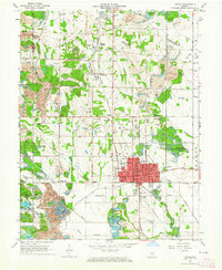
1963 Map of Linton
USGS Topo · Published 1973About this map
The industrial and extractive landscape of Greene County is on full display here, centered on the city of Linton and the surrounding coal fields. This 1963 revision highlights an era where mining operations had significantly reshaped the terrain, leaving behind numerous strip mines and reservoirs like Sunflower Pond and County Line Lake. A notable point of pride for the region is the Historical Marker located just east of the city, identifying a past geographic center of the United States.
Find a feature on this map
78 named features on this map. Tap any name to fly to it.
Don’t see what you’re looking for? This feature index may not catch every label — zoom into the map to look around manually.
Map Details
Editions of this 1963 Linton Map
4 editions found
Other maps of this area

1938 · Coal City
USGS Topo · 1:24,000

1938 · Switz City
USGS Topo · 1:24,000

1940 · Linton
USGS Topo · 1:24,000

1940 · Jasonville
USGS Topo · 1:24,000

1943 · Lyons
USGS Topo · 1:24,000

1943 · Hymera
USGS Topo · 1:24,000

1943 · Sandborn
USGS Topo · 1:24,000

1943 · Dugger
USGS Topo · 1:24,000

1944 · Bucktown
USGS Topo · 1:24,000

1947 · Switz City
USGS Topo · 1:24,000