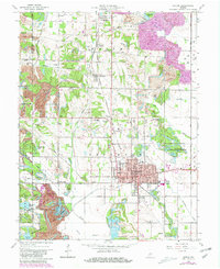
1963 Map of Linton
USGS Topo · Published 1981About this map
The industrial and extractive history of Greene and Sullivan Counties is etched into the landscape surrounding Linton. Large Strip Mine excavations dominate the western terrain, creating a complex series of ridges and basins now part of the Greene-Sullivan State Forest, including Reservoir No 26 and Reservoir No 29. This survey highlights the region's historical importance as a geographic hub, notably featuring a Historical Marker signifying the nation's former demographic center.
Find a feature on this map
60 named features on this map. Tap any name to fly to it.
Don’t see what you’re looking for? This feature index may not catch every label — zoom into the map to look around manually.
Map Details
Editions of this 1963 Linton Map
4 editions found
Other maps of this area

1938 · Coal City
USGS Topo · 1:24,000

1938 · Switz City
USGS Topo · 1:24,000

1940 · Linton
USGS Topo · 1:24,000

1940 · Jasonville
USGS Topo · 1:24,000

1943 · Lyons
USGS Topo · 1:24,000

1943 · Hymera
USGS Topo · 1:24,000

1943 · Sandborn
USGS Topo · 1:24,000

1943 · Dugger
USGS Topo · 1:24,000

1944 · Bucktown
USGS Topo · 1:24,000

1947 · Switz City
USGS Topo · 1:24,000