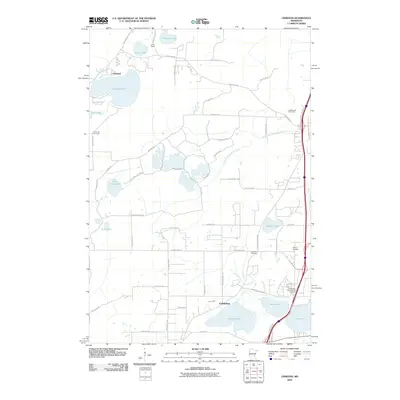
2010 Map of Linwood
USGS Topo · Published 2010About this map
Linwood and Columbus anchor a landscape defined by an intricate network of glacial lakes and wetlands in Anoka County. This 2010 survey details a region where residential development and recreational spaces like Greenwood Golf Links and Camp Salie interface with the natural drainage of the South Branch Sunrise River. The map is particularly useful for genealogists, as it identifies several established burial grounds including Victor Hill Cemetery, Oak Park Cemetery, and Calvary Cemetery. The northern portion is dominated by the large basin of Linwood Lake and Island Lake, while the southern reaches show the vicinity of Howard Lake and Clear Lake. This documentation of the area’s hydrography and road network, from Viking Blvd NE to Kettle River Blvd, illustrates the suburban character of the exurban Twin Cities during the early 21st century.
Find a feature on this map
66 named features on this map. Tap any name to fly to it.
Don’t see what you’re looking for? This feature index may not catch every label — zoom into the map to look around manually.
Map Details
Editions of this 2010 Linwood Map
This is the sole edition of this map. No revisions or reprints were ever made.
Other maps of this area

1902 · White Bear
USGS Topo · 1:62,500

1948 · Stillwater
USGS Topo · 1:62,500

1949 · Stillwater
USGS Topo · 1:62,500

1952 · Centerville
USGS Topo · 1:24,000

1953 · Stillwater
USGS Topo · 1:250,000

1954 · Hugo
USGS Topo · 1:24,000

1955 · Circle Pines
USGS Topo · 1:24,000

1955 · Forest Lake
USGS Topo · 1:62,500

1955 · Isanti
USGS Topo · 1:62,500
1955 · New Brighton
USGS Topo · 1:62,500