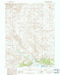
1987 Map of Linwood Canyon
USGS Topo · Published 1987About this map
Flaming Gorge National Recreation Area dominates the southeastern portion of this landscape, where the waters of the Flaming Gorge Reservoir meet the rugged terrain of Lucerne Valley. The convergence of Henrys Fork and Cottonwood Creek defines the local hydrology, feeding into Linwood Bay. This 1987 provisional survey illustrates a transition from natural watercourses to managed irrigation, evidenced by the presence of the Peoples Canal and Sheep Creek Canal. Significant landforms like Twin Buttes and the namesake Linwood Canyon provide clear markers for navigating the high desert environment. Small-scale industrial activity is noted at a Gravel Pit near the river, while a Gaging Station monitors the flow of the Henrys Fork before it joins the reservoir.
Find a feature on this map
18 named features on this map. Tap any name to fly to it.
Don’t see what you’re looking for? This feature index may not catch every label — zoom into the map to look around manually.
Map Details
Editions of this 1987 Linwood Canyon Map
This is the sole edition of this map. No revisions or reprints were ever made.
Other maps of this area

1885 · Ashley
USGS Topo · 1:250,000

1906 · Marsh Peak
USGS Topo · 1:125,000

1908 · Marsh Peak
USGS Topo · 1:125,000

1952 · Flaming Gorge
USGS Topo · 1:24,000

1954 · Vernal
USGS Topo · 1:250,000

1954 · Rock Springs
USGS Topo · 1:250,000

1958 · Vernal
USGS Topo · 1:250,000

1958 · Rock Springs
USGS Topo · 1:250,000

1960 · Vernal
USGS Topo · 1:250,000

1962 · Rock Springs
USGS Topo · 1:250,000