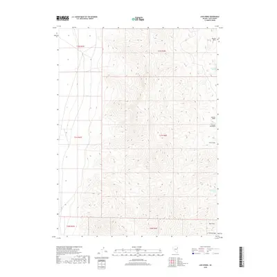
2018 Map of Lion Spring
USGS Topo · Published 2018About this map
Goshute Peak anchors the southern boundary of this high-elevation terrain in Elko County, where the steep topography of the Goshute Mountains drops away into the Goshute Valley. The landscape is defined by its critical water sources, which appear as a series of isolated points including Chokecherry Springs, Serviceberry Spring, and the central Lion Spring. These names hint at the local flora and fauna that sustain life in this arid environment. To the north, Morgan Basin provides a natural catchment above the rugged descent of Lion Canyon. This 2018 survey by the U.S. Geological Survey illustrates the complex township and range system overlaying the natural features, marking a specific moment in the contemporary management of Nevada's interior basins and ranges.
Find a feature on this map
9 named features on this map. Tap any name to fly to it.
Don’t see what you’re looking for? This feature index may not catch every label — zoom into the map to look around manually.
Map Details
Editions of this 2018 Lion Spring Map
This is the sole edition of this map. No revisions or reprints were ever made.
Other maps of this area

1955 · Elko
USGS Topo · 1:250,000

1958 · Elko
USGS Topo · 1:250,000

1962 · Elko
USGS Topo · 1:250,000

1965 · Elko
USGS Topo · 1:250,000

1971 · Decoy
USGS Topo · 1:24,000

1972 · Morgan Pass
USGS Topo · 1:24,000

1972 · Lion Spring
USGS Topo · 1:24,000

1972 · Ferguson Mtn.
USGS Topo · 1:24,000

1972 · Ola
USGS Topo · 1:24,000
1972 · Spring Gulch
USGS Topo · 1:24,000