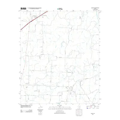
2012 Map of Lipan
USGS Topo · Published 2012About this map
Lipan sits at the heart of this North Texas landscape, where the local road network converges near the winding path of Kickapoo Cr. The map reveals a rural community structured by its watercourses and small family landmarks, with New Salem located to the northwest along the route to Landreth Cem. The terrain is defined by distinct elevations such as Potato Hill and Double Mtn, providing natural landmarks amidst the creek drainage systems of Rock Cr and Rocky Bluff Cr. Genealogists and local historians can locate several burial grounds including Evergreen Cem and Hill Cem, which are tucked away near local thoroughfares like FM-4 and New Salem Rd. The far northeastern corner is touched by the Brazos River, while smaller water features like Baileys Lake and Weaver Br suggest the importance of local water management in this agricultural region.
Find a feature on this map
65 named features on this map. Tap any name to fly to it.
Don’t see what you’re looking for? This feature index may not catch every label — zoom into the map to look around manually.
Map Details
Editions of this 2012 Lipan Map
This is the sole edition of this map. No revisions or reprints were ever made.
Other maps of this area

1889 · Granbury
USGS Topo · 1:125,000

1890 · Stephenville
USGS Topo · 1:125,000

1891 · Weatherford
USGS Topo · 1:125,000

1891 · Palo Pinto
USGS Topo · 1:125,000

1893 · Weatherford
USGS Topo · 1:125,000

1918 · Palo Pinto
USGS Topo · 1:125,000

1920 · Stephenville
USGS Topo · 1:125,000

1925 · Palo Pinto 4-b
USGS Topo · 1:48,000

1931 · Dennis
USGS Topo · 1:62,500

1931 · Santo
USGS Topo · 1:62,500