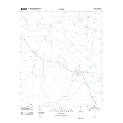
2011 Map of Lisman
USGS Topo · Published 2011About this map
Lisman sits as a central hub in Choctaw County, connected by a network of rural routes and historic settlements like Pushmataha and Cromwell. The landscape is defined by the winding course of the Bogue Chitto and its many tributaries, including Tuckabum Creek and Yantley Creek, which carve through the terrain near landmarks like Scott Mountain. This 2011 survey reveals a deeply rooted community, evidenced by numerous historical burial sites such as Sardis Cemetery, Eureka Cemetery, and the Episcopal Cemetery. The southern portion of the map is shaped by the topography of Mose Spur and the settlement of Riderwood, where the geography transitions toward Rocky Branch. The map's detailed road network, including Ruffintown Rd and Mount Nebo Rd, illustrates the persistent pattern of small-town Alabama life as it continued into the early 21st century.
Find a feature on this map
67 named features on this map. Tap any name to fly to it.
Don’t see what you’re looking for? This feature index may not catch every label — zoom into the map to look around manually.
Map Details
Editions of this 2011 Lisman Map
This is the sole edition of this map. No revisions or reprints were ever made.
Other maps of this area

1953 · Meridian
USGS Topo · 1:250,000

1957 · Meridian
USGS Topo · 1:250,000

1965 · Meridian
USGS Topo · 1:250,000

1971 · Gaston
USGS Topo · 1:24,000

1974 · Yantley
USGS Topo · 1:24,000

1974 · Ward
USGS Topo · 1:24,000

1974 · Lisman
USGS Topo · 1:24,000
1974 · Hinton
USGS Topo · 1:24,000
1974 · Land
USGS Topo · 1:24,000
1978 · Whynot
USGS Topo · 1:24,000