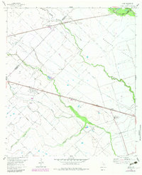
1960 Map of Lissie
USGS Topo · Published 1983About this map
The agricultural landscape of Bernard Prairie is defined here by a sophisticated network of water management and rail transportation straddling the Colorado and Wharton County line. The Southern Pacific railroad serves as the primary corridor for the region's economy, connecting the small settlements of Lissie, Nottawa, and Chesterville. In Lissie, a prominent Rice Mill stands near the tracks, illustrating the area's specialized farming heritage, while the Gas Plant and scattered wells of the nearby Oil Field point to the subterranean resources that diversified the local economy. Water control is central to this prairie environment, shown through the Chesterville Line Canal and the meandering courses of West Bernard Creek and Middle Bernard Creek. Small family landmarks, such as the Hoefer siding and a rural Cem, provide valuable points of reference for genealogists tracking early twentieth-century residents.
Find a feature on this map
18 named features on this map. Tap any name to fly to it.
Don’t see what you’re looking for? This feature index may not catch every label — zoom into the map to look around manually.
Map Details
Editions of this 1960 Lissie Map
2 editions found
Other maps of this area

1952 · Egypt
USGS Topo · 1:24,000

1953 · Hungerford
USGS Topo · 1:24,000

1953 · Seguin
USGS Topo · 1:250,000

1956 · Wallis
USGS Topo · 1:62,500

1957 · Eagle Lake
USGS Topo · 1:62,500

1958 · Seguin
USGS Topo · 1:250,000

1959 · Bonus
USGS Topo · 1:24,000

1960 · Lissie
USGS Topo · 1:24,000

1960 · Wallis
USGS Topo · 1:24,000
1960 · East Bernard
USGS Topo · 1:24,000