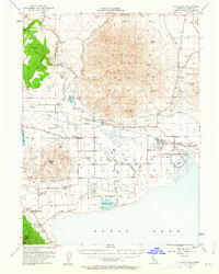
1954 Map of Litchfield
USGS Topo · Published 1963About this map
Shaffer Mountain dominates the central landscape of this mid-century Lassen County survey, standing between the arid Mud Flat and the expansive northern reaches of Honey Lake. The settlement pattern follows the Southern Pacific rail line and the Susan River, which feeds into a complex network of irrigation features including the Eagle Lake Ditch and Hartson Slough. Local history is visible in the varied land uses of the era, from the waterfowl conservation efforts at the Wildfowl Management Area (Dakin Unit) to the ancient Petroglyphs near Petes Creek. Small rural communities like Litchfield, Standish, and Wendel serve as anchors for the surrounding ranching and transit economy. The map also records early educational and social landmarks, such as the Lake School near Buntingville and a Cem south of Standish, providing a clear view of the region's human geography before modern development.
Find a feature on this map
37 named features on this map. Tap any name to fly to it.
Don’t see what you’re looking for? This feature index may not catch every label — zoom into the map to look around manually.
Map Details
Editions of this 1954 Litchfield Map
3 editions found
Other maps of this area

1886 · Honey Lake
USGS Topo · 1:250,000

1891 · Honey Lake
USGS Topo · 1:250,000

1893 · Honey Lake
USGS Topo · 1:250,000

1950 · Kettle Rock
USGS Topo · 1:62,500

1950 · Milford
USGS Topo · 1:62,500

1954 · Susanville
USGS Topo · 1:62,500

1954 · Wendel
USGS Topo · 1:62,500

1954 · Litchfield
USGS Topo · 1:62,500

1954 · Karlo
USGS Topo · 1:62,500

1954 · Doyle
USGS Topo · 1:62,500