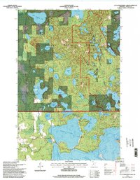
1996 Map of Little Bowstring Lake
USGS Topo · Published 1998About this map
Chippewa National Forest and Bowstring State Forest define this lakeland region in Itasca County, where a dense network of water bodies served as the foundation for both early settlement and late 20th-century recreation. The small community of Suomi stands near the northern edge, anchored by the Suomi Church, reflecting the area's heritage. To the east, the Suomi Hills Recreation Area contains a specialized trail system among the glacial topography of the Suomi Hills. Massive basins like Deer Lake and Moose Lake dominate the southern half of the map, while smaller interior waters such as Cottonwood Lake and Little Bowstring Lake provide numerous boat access points. The transition from timber management to recreational use is evident in the preservation of the landscape and the presence of historic landmarks like Clara Church in the southwest corner.
Find a feature on this map
54 named features on this map. Tap any name to fly to it.
Don’t see what you’re looking for? This feature index may not catch every label — zoom into the map to look around manually.
Map Details
Editions of this 1996 Little Bowstring Lake Map
This is the sole edition of this map. No revisions or reprints were ever made.
Other maps of this area

1919 · Marcell
USGS Topo · 1:62,500

1953 · Cohasset East
USGS Topo · 1:24,000

1953 · Cohasset West
USGS Topo · 1:24,000

1954 · Hibbing
USGS Topo · 1:250,000

1957 · Hibbing
USGS Topo · 1:250,000

1958 · Hibbing
USGS Topo · 1:250,000

1964 · Hibbing
USGS Topo · 1:250,000

1970 · Deer River NE
USGS Topo · 1:24,000

1970 · Wabana Lake
USGS Topo · 1:24,000

1970 · Clubhouse Lake
USGS Topo · 1:24,000