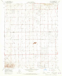
1965 Map of Little Buttes
USGS Topo · Published 1967About this map
Antelope Acres sits at the southern edge of this mid-1960s survey, marking a pocket of residential development in the high desert of the Antelope Valley. The landscape is defined by the sharp transition between the volcanic outcrops of Little Buttes and the sprawling grid of the California High Desert. This area, straddling the Kern Co Los Angeles Co line, is meticulously charted with an emphasis on water infrastructure, evidenced by the numerous wells and water tanks required to sustain life and agriculture in this arid environment. Key local landmarks include the Rogers School and a Radio Facility, providing glimpses into the civic and technological infrastructure of the mid-century era. The map traces the rigid geometry of the valley floor, where thoroughfares like Rosamond Blvd and Gaskell Street cut across the alluvial plains toward the distant Antelope Buttes.
Find a feature on this map
47 named features on this map. Tap any name to fly to it.
Don’t see what you’re looking for? This feature index may not catch every label — zoom into the map to look around manually.
Map Details
Editions of this 1965 Little Buttes Map
2 editions found
Other maps of this area

1915 · Elizabeth Lake
USGS Topo · 1:125,000

1917 · Elizabeth Lake
USGS Topo · 1:125,000

1931 · Little Buttes
USGS Topo · 1:24,000

1931 · Esperanza School
USGS Topo · 1:24,000

1934 · Little Buttes
USGS Topo · 1:24,000

1934 · Esperanza School
USGS Topo · 1:24,000

1943 · Rosamond
USGS Topo · 1:62,500

1943 · Willow Springs
USGS Topo · 1:62,500
1947 · Rosamond
USGS Topo · 1:24,000

1947 · Soledad Mountain
USGS Topo · 1:24,000