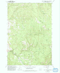
1993 Map of Little Catherine Creek
USGS Topo · Published 1993About this map
Catherine Creek State Park occupies a central role in this pocket of Union County, where the canyon floor transitions toward the high peaks of the Eagle Cap Wilderness. The landscape is defined by the converging drainage systems of Catherine Creek and Little Catherine Creek, which carve through the dense timber of the Whitman National Forest. Local landmarks like Billy Small Meadow and Little Catherine Meadows indicate the presence of seasonal grazing lands and water sources amidst the steep terrain. Evidence of high-country navigation is visible through the primitive Merry-Go-Round Road and the Pack Trail that crosses the Wilderness Boundary near Bald Mountain. Peaks such as South Baldy and Crib Point anchor the high ridges, overlooking several remote water sources like Bearwallow Spring.
Find a feature on this map
23 named features on this map. Tap any name to fly to it.
Don’t see what you’re looking for? This feature index may not catch every label — zoom into the map to look around manually.
Map Details
Editions of this 1993 Little Catherine Creek Map
This is the sole edition of this map. No revisions or reprints were ever made.
Other maps of this area

1906 · Telocaset
USGS Topo · 1:125,000

1955 · Grangeville
USGS Topo · 1:250,000

1959 · Grangeville
USGS Topo · 1:250,000

1965 · China Cap
USGS Topo · 1:24,000

1965 · Flagstaff Butte
USGS Topo · 1:24,000

1965 · Union
USGS Topo · 1:24,000

1965 · Medical Springs
USGS Topo · 1:24,000

1965 · Cove
USGS Topo · 1:24,000

1965 · Little Catherine Creek
USGS Topo · 1:24,000
1965 · Telocaset
USGS Topo · 1:24,000