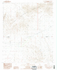
1988 Map of Little Chuckwalla Mountains
USGS Topo · Published 1988About this map
The Little Chuckwalla Mountains dominate the northern terrain of this 1980s quadrangle, where the land falls away into the Black Hills to the south. This arid landscape is marked by a history of resource exploration, indicated by numerous unnamed Prospects and a specific Prospect clustered near the Black Hills. A notable geological point of interest is the Geode Beds located in the southeastern quadrant, a site likely of interest to rockhounds and mineral collectors. The map also records the jurisdictional boundary between Riverside Co and Imperial Co, as well as the path of the Trans Line traversing the central desert plains. The lack of established settlements emphasizes the specialized land use in this desert region, focused on utility infrastructure and small-scale mineral prospecting.
Find a feature on this map
7 named features on this map. Tap any name to fly to it.
Don’t see what you’re looking for? This feature index may not catch every label — zoom into the map to look around manually.
Map Details
Editions of this 1988 Little Chuckwalla Mountains Map
3 editions found
Other maps of this area

1942 · Blythe
USGS Topo · 1:250,000

1952 · Mc Coy Spring
USGS Topo · 1:62,500

1952 · Sidewinder Well
USGS Topo · 1:62,500

1953 · Palo Verde Mountains
USGS Topo · 1:62,500

1953 · Chuckwalla Spring
USGS Topo · 1:62,500

1954 · Salton Sea
USGS Topo · 1:250,000

1955 · Salton Sea
USGS Topo · 1:250,000

1959 · Salton Sea
USGS Topo · 1:250,000

1963 · Salton Sea
USGS Topo · 1:250,000

1965 · Salton Sea
USGS Topo · 1:250,000