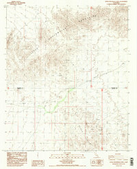
1988 Map of Little Chuckwalla Mts
USGS Topo · Published 1988About this map
The Little Chuckwalla Mountains dominate the northern landscape of this desert terrain, where historical prospecting and sparse water sources define the human footprint. Recorded in the late 1980s, the map reveals a rugged geography marked by numerous prospects and specialized geologic features like the Geode Beds in the southern reaches. The boundary between Riverside Co and Imperial Co bisects the region, which is navigated by the distinctive Trans Line corridor. Vital water points, essential for any desert activity, are located at Chuckwalla Spring and Pegleg Well, illustrating the limited but critical infrastructure found in the Black Hills area.
Find a feature on this map
9 named features on this map. Tap any name to fly to it.
Don’t see what you’re looking for? This feature index may not catch every label — zoom into the map to look around manually.
Map Details
Editions of this 1988 Little Chuckwalla Mts Map
3 editions found
Other maps of this area

1942 · Blythe
USGS Topo · 1:250,000

1952 · Mc Coy Spring
USGS Topo · 1:62,500

1952 · Sidewinder Well
USGS Topo · 1:62,500

1953 · Palo Verde Mountains
USGS Topo · 1:62,500

1953 · Chuckwalla Spring
USGS Topo · 1:62,500

1954 · Salton Sea
USGS Topo · 1:250,000

1955 · Salton Sea
USGS Topo · 1:250,000

1959 · Salton Sea
USGS Topo · 1:250,000

1963 · Salton Sea
USGS Topo · 1:250,000

1965 · Salton Sea
USGS Topo · 1:250,000