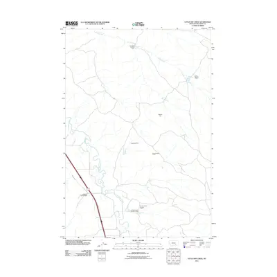
2011 Map of Little Dry Creek
USGS Topo · Published 2011About this map
The Little Bighorn River meanders through this portion of Big Horn County, defining a landscape shaped by both natural drainage and early 21st-century water management. Distinctive landforms such as Haystack Butte and the curiously named Abbots Urn rise above the surrounding terrain, while Crooked Arm Coulee cuts into the plains. The map reveals an intricate network of small-scale dams, including the D S Scott Number 1 Dam and multiple structures named for the Crow and Orchowski families, suggesting a highly managed local hydrology for ranching or agriculture. Human infrastructure is concentrated along the river corridor, where the Agency Canal and Frontage Rd parallel the waterway, providing a detailed look at the rural transport and irrigation systems in place before further modern development.
Find a feature on this map
14 named features on this map. Tap any name to fly to it.
Don’t see what you’re looking for? This feature index may not catch every label — zoom into the map to look around manually.
Map Details
Editions of this 2011 Little Dry Creek Map
This is the sole edition of this map. No revisions or reprints were ever made.
Other maps of this area

1894 · Fort Custer
USGS Topo · 1:125,000

1954 · Hardin
USGS Topo · 1:250,000

1957 · Hardin
USGS Topo · 1:250,000

1958 · Hardin
USGS Topo · 1:250,000

1960 · Ninemile Point
USGS Topo · 1:24,000

1960 · Hardin
USGS Topo · 1:24,000
1960 · Prante Ranch
USGS Topo · 1:24,000

1967 · Crow Agency NE
USGS Topo · 1:24,000

1967 · Crow Agency SE
USGS Topo · 1:24,000
1967 · Crow Agency
USGS Topo · 1:24,000