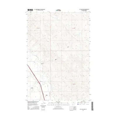
2017 Map of Little Dry Creek
USGS Topo · Published 2017About this map
Crow Agency sits at the southwestern corner of this Montana landscape, where the Little Bighorn River cuts through the broad Little Bighorn Valley. The terrain is defined by its drainage patterns, with the Agency Canal running parallel to the river and the prominent Crooked Arm Coulee carving into the western hills. To the east, the land rises into more complex topography marked by local landmarks such as Abbots Urn and Haystack Butte.
Find a feature on this map
17 named features on this map. Tap any name to fly to it.
Don’t see what you’re looking for? This feature index may not catch every label — zoom into the map to look around manually.
Map Details
Editions of this 2017 Little Dry Creek Map
This is the sole edition of this map. No revisions or reprints were ever made.
Other maps of this area

1894 · Fort Custer
USGS Topo · 1:125,000

1954 · Hardin
USGS Topo · 1:250,000

1957 · Hardin
USGS Topo · 1:250,000

1958 · Hardin
USGS Topo · 1:250,000

1960 · Ninemile Point
USGS Topo · 1:24,000

1960 · Hardin
USGS Topo · 1:24,000
1960 · Prante Ranch
USGS Topo · 1:24,000

1967 · Crow Agency NE
USGS Topo · 1:24,000

1967 · Crow Agency SE
USGS Topo · 1:24,000
1967 · Crow Agency
USGS Topo · 1:24,000