
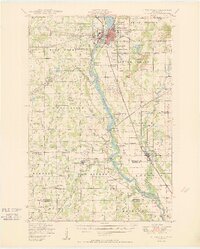
1950 Map of Little Falls
USGS Topo · Published 1950About this map
The Mississippi River defines the central axis of this Morrison County landscape, flowing past the industrial hub of Little Falls and southward toward Blanchard Dam. The map captures a mid-century rural network defined by its small-town civic centers and an extensive system of one-room schoolhouses, from School No 24 in the north to School No 121 near Rice Village. The presence of numerous township halls, including the Swan River Town Hall and Little Falls Town Hall, indicates a strong pattern of local governance and community identity during this post-war era.
Find a feature on this map
92 named features on this map. Tap any name to fly to it.
Don’t see what you’re looking for? This feature index may not catch every label — zoom into the map to look around manually.
Map Details
Editions of this 1950 Little Falls Map
2 editions found
Other maps of this area

1947 · Flensburg
USGS Topo · 1:25,000

1948 · Belle Prairie
USGS Topo · 1:62,500

1948 · Pierz
USGS Topo · 1:62,500

1948 · Lastrup
USGS Topo · 1:62,500

1948 · Cushing
USGS Topo · 1:62,500

1948 · Little Falls
USGS Topo · 1:62,500

1950 · Lastrup
USGS Topo · 1:62,500

1950 · Swanville
USGS Topo · 1:62,500

1950 · Belle Prairie
USGS Topo · 1:62,500

1950 · Pierz
USGS Topo · 1:62,500