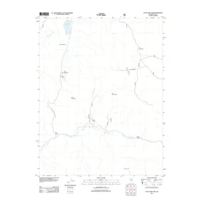
2012 Map of Little Fish Lake
USGS Topo · Published 2012About this map
Hot Creek flows through this high-desert landscape in Nye County, anchoring a series of vital water sources including the Old Dugan Place Hot Spring and Upper Warm Spring. The terrain is defined by the significant rise of the Hot Creek Range to the east and the expansive Little Fish Lake Valley to the west, where Little Fish Lake sits at the northern end. This area illustrates the classic Basin and Range morphology of Nevada, where isolated ranching outposts like the Old Dugan Ranch relied on scattered groundwater points such as Page Springs and Gold Spring. A network of primitive routes, including Natl Forest Develop Road 139 Rd, connects these remote landforms, winding through Box Canyon and across Fourmile Flats.
Find a feature on this map
24 named features on this map. Tap any name to fly to it.
Don’t see what you’re looking for? This feature index may not catch every label — zoom into the map to look around manually.
Map Details
Editions of this 2012 Little Fish Lake Map
This is the sole edition of this map. No revisions or reprints were ever made.
Other maps of this area

1956 · Tonopah
USGS Topo · 1:250,000

1959 · Tonopah
USGS Topo · 1:250,000

1962 · Tonopah
USGS Topo · 1:250,000

1967 · Blue Jay Spring
USGS Topo · 1:24,000

1967 · Upper Fish Lake
USGS Topo · 1:24,000

1967 · Morey Peak
USGS Topo · 1:24,000

1968 · Tybo
USGS Topo · 1:62,500

1968 · Morey Peak
USGS Topo · 1:62,500
1968 · Flagstaff Mtn.
USGS Topo · 1:24,000
1968 · Hobble Canyon
USGS Topo · 1:24,000