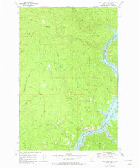
1969 Map of Little Green Mountain
USGS Topo · Published 1982About this map
Dworshak Reservoir North Fork Clearwater River dominates the eastern drainage of this Idaho landscape, reflecting a transformative era in Clearwater County’s water management. The reservoir's reach is marked by navigation points such as Mile 32 and Mile 24, indicating the scale of this impoundment along the North Fork Clearwater River. Inland, the terrain is defined by steep ridges and narrow drainages, including the oddly named Pick and Pan Creek and Baldy Bear Creek.
Find a feature on this map
27 named features on this map. Tap any name to fly to it.
Don’t see what you’re looking for? This feature index may not catch every label — zoom into the map to look around manually.
Map Details
Editions of this 1969 Little Green Mountain Map
3 editions found
Other maps of this area

1923 · Washington Creek
USGS Topo · 1:125,000

1936 · Boehls Butte
USGS Topo · 1:48,000

1938 · Headquarters
USGS Topo · 1:48,000

1943 · Boehls Butte
USGS Topo · 1:62,500

1944 · Headquarters
USGS Topo · 1:62,500

1955 · Pullman
USGS Topo · 1:250,000

1956 · Hamilton
USGS Topo · 1:250,000

1958 · Pullman
USGS Topo · 1:250,000

1959 · Hamilton
USGS Topo · 1:250,000

1960 · Hamilton
USGS Topo · 1:250,000