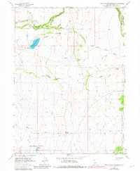
1963 Map of Little Juniper Reservoir
USGS Topo · Published 1983About this map
Little Juniper Reservoir and Flournoy Reservoir dominate the hydrology of this high-elevation landscape within the Modoc National Forest. This 1963 survey, updated in the early 1980s, reveals an intricate network of water management features, including a ditch system and numerous springs such as Nelson Springs and Wall Springs. The terrain is defined by the headwaters of several drainage systems, including Big Juniper Creek and Little Juniper Creek, which cut through the undulating plateaus of Modoc County. The absence of paved roads and the reliance on a network of jeep trails underscore the working, utilitarian nature of the land, primarily used for cattle grazing and timber management. Along the northern boundary, the South Fork Fitzhugh Creek flows through steepening terrain, while the spillway elevations noted at both reservoirs provide precise data on the area's water engineering.
Find a feature on this map
15 named features on this map. Tap any name to fly to it.
Don’t see what you’re looking for? This feature index may not catch every label — zoom into the map to look around manually.
Map Details
Editions of this 1963 Little Juniper Reservoir Map
4 editions found
Other maps of this area

1886 · Alturas
USGS Topo · 1:250,000

1892 · Alturas
USGS Topo · 1:250,000

1954 · Alturas
USGS Topo · 1:250,000

1958 · Alturas
USGS Topo · 1:250,000

1961 · Alturas
USGS Topo · 1:62,500

1962 · Alturas
USGS Topo · 1:250,000

1962 · Tule Mountain
USGS Topo · 1:24,000

1962 · Jess Valley
USGS Topo · 1:24,000

1962 · Likely
USGS Topo · 1:62,500

1963 · Little Juniper Reservoir
USGS Topo · 1:24,000