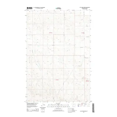
2014 Map of Little Pine Creek
USGS Topo · Published 2014About this map
Little Pine Cr and the larger Pine Cr define the drainage patterns of this Fallon County landscape, where the High Plains break into a complex network of coulees and ridges. The 2014 survey reveals a remote ranching and agricultural region structured by the Public Land Survey System, with township boundaries for T7N and T6N dividing the territory. Transportation is limited to a sparse grid of gravel and access roads, such as Pleyna Rd S and Pine Creek Rd, which provide essential links for the isolated homesteads and grazing lands. Named access routes like Fried Acc and Janz Acc suggest the enduring presence of local families managing these vast tracts. The inclusion of the Little Pine Trl indicates a transition from maintained vehicle roads to more primitive tracks, essential for navigating the interior breaks near Hay Cr.
Find a feature on this map
15 named features on this map. Tap any name to fly to it.
Don’t see what you’re looking for? This feature index may not catch every label — zoom into the map to look around manually.
Map Details
Editions of this 2014 Little Pine Creek Map
This is the sole edition of this map. No revisions or reprints were ever made.
Other maps of this area

1953 · Miles City
USGS Topo · 1:250,000

1957 · Miles City
USGS Topo · 1:250,000

1958 · Miles City
USGS Topo · 1:250,000

1981 · Baker
USGS Topo · 1:100,000

1981 · Harmon Butte
USGS Topo · 1:24,000

1981 · South Sandstone Reservoir
USGS Topo · 1:24,000

1981 · Little Pine Creek
USGS Topo · 1:24,000

1981 · Baker NW
USGS Topo · 1:24,000

1981 · Seven-Up Butte
USGS Topo · 1:24,000
1981 · Sportsman Pond
USGS Topo · 1:24,000