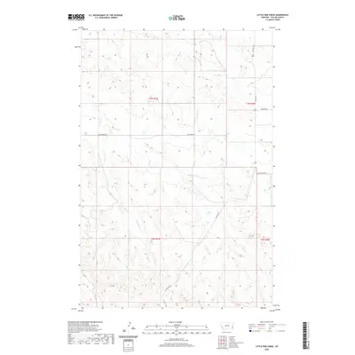
2020 Map of Little Pine Creek
USGS Topo · Published 2020About this map
Little Pine Cr and its winding tributaries dominate this portion of the Fallon County landscape, showing the drainage patterns of eastern Montana's high plains. The terrain is marked by the branching systems of Pine Creek, Hay Creek, and Brush Creek, which have carved distinctive coulees and ridges through the ranching country. The road network reflects a structured land-use pattern, with thoroughfares like Pine Creek Rd and Plevna Rd S following the section lines of the Public Land Survey System. These routes, along with Sandstone Rd and Sunny Bank Rd, serve as the primary connectors for the rural homesteads and operations across townships T7N R57E and T6N R58E. The survey captures a moment of modern rural infrastructure, where established gravel roads provide access to the expansive open spaces between the creek beds.
Find a feature on this map
12 named features on this map. Tap any name to fly to it.
Don’t see what you’re looking for? This feature index may not catch every label — zoom into the map to look around manually.
Map Details
Editions of this 2020 Little Pine Creek Map
This is the sole edition of this map. No revisions or reprints were ever made.
Other maps of this area

1953 · Miles City
USGS Topo · 1:250,000

1957 · Miles City
USGS Topo · 1:250,000

1958 · Miles City
USGS Topo · 1:250,000

1981 · Baker
USGS Topo · 1:100,000

1981 · Harmon Butte
USGS Topo · 1:24,000

1981 · South Sandstone Reservoir
USGS Topo · 1:24,000

1981 · Little Pine Creek
USGS Topo · 1:24,000

1981 · Baker NW
USGS Topo · 1:24,000

1981 · Seven-Up Butte
USGS Topo · 1:24,000
1981 · Sportsman Pond
USGS Topo · 1:24,000