1960 Map of Little Prairie
USGS Topo · Published 1964About this map
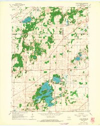
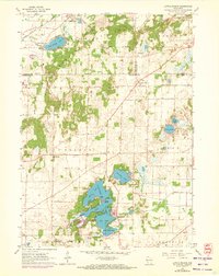
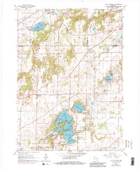
Kettle Moraine State Forest dominates the northern reaches of this glacial landscape, where the irregular topography is defined by kames, kettles, and a dense network of water bodies. The Milwaukee St Paul and Pacific railroad cuts across the northwest corner near Palmyra, providing a historical industrial contrast to the recreational focus seen further south. The Lauderdale Lakes system, including Middle Lake and Mill Lake, shows a high concentration of shoreline development, including Don Jean Bay and the narrow Long Point.
Find a feature on this map
35 named features on this map. Tap any name to fly to it.
Don’t see what you’re looking for? This feature index may not catch every label — zoom into the map to look around manually.
Map Details
Editions of this 1960 Little Prairie Map
3 editions found
Other maps of this area

1892 · Whitewater
USGS Topo · 1:62,500

1892 · Eagle
USGS Topo · 1:62,500

1893 · Delavan
USGS Topo · 1:62,500

1893 · Whitewater
USGS Topo · 1:62,500

1893 · Geneva
USGS Topo · 1:62,500

1894 · Eagle
USGS Topo · 1:62,500

1897 · Eagle
USGS Topo · 1:62,500

1903 · Whitewater
USGS Topo · 1:62,500

1904 · Lake Geneva
USGS Topo · 1:62,500

1906 · Eagle
USGS Topo · 1:62,500