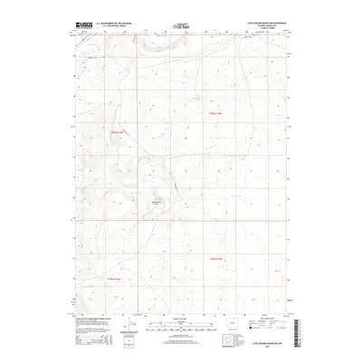
2015 Map of Little Round Mountain
USGS Topo · Published 2015About this map
Emigrant Trl winds through this high-altitude landscape in Lincoln County, marking a corridor shaped by historic westward movement across the Wyoming range. The terrain is defined by the prominent Little Round Mtn, which serves as a central landmark between the drainage of Hams Fork to the north and the seasonal flow of Dry Muddy Cr to the south. Critical water sources like Little Round Mountain Spring and Coyote Spring are mapped here, highlighting the essential points of relief for travelers and livestock in an otherwise arid environment. Modern infrastructure, such as Sageview Dr and Wagon Wheel Rd, parallels these older paths, reflecting how contemporary access routes often trace the same topographical advantages utilized by early pioneers and settlers.
Find a feature on this map
12 named features on this map. Tap any name to fly to it.
Don’t see what you’re looking for? This feature index may not catch every label — zoom into the map to look around manually.
Map Details
Editions of this 2015 Little Round Mountain Map
This is the sole edition of this map. No revisions or reprints were ever made.
Other maps of this area

1954 · Ogden
USGS Topo · 1:250,000

1954 · Kemmerer
USGS Topo · 1:62,500

1958 · Ogden
USGS Topo · 1:250,000

1960 · Ogden
USGS Topo · 1:250,000

1962 · Cumberland Gap
USGS Topo · 1:24,000

1962 · Elkol
USGS Topo · 1:24,000

1969 · Willow Springs
USGS Topo · 1:24,000

1969 · Roberson Creek
USGS Topo · 1:24,000

1969 · Hampton
USGS Topo · 1:24,000
1969 · Mulkay Spring
USGS Topo · 1:24,000