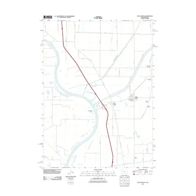
2011 Map of Little Sioux
USGS Topo · Published 2011About this map
Little Sioux and the neighboring settlement of River Sioux occupy the fertile plains along the eastern bank of the Missouri River in this 2011 survey. The landscape is defined by the complex water management systems of Harrison County, including the Monona Harrison Ditch and the Soldier River Cutoff, which facilitate agriculture in this flood-prone river valley. The map reveals a high density of rural burial grounds, such as Fountainbleau Cemetery, Conyers Cemetery, and Ruffcorn Cemetery, providing valuable points of interest for genealogists and local historians tracking early settlers. To the east, the topography shifts abruptly at Murray Hill Overlook, marking the rise of the Loess Hills above the alluvial flats. Transportation is anchored by the Interstate and the local grid, while the Little Sioux Post Office remains a central landmark in the township.
Find a feature on this map
51 named features on this map. Tap any name to fly to it.
Don’t see what you’re looking for? This feature index may not catch every label — zoom into the map to look around manually.
Map Details
Editions of this 2011 Little Sioux Map
This is the sole edition of this map. No revisions or reprints were ever made.
Other maps of this area

1954 · Omaha
USGS Topo · 1:250,000

1955 · Fremont
USGS Topo · 1:250,000

1957 · Fremont
USGS Topo · 1:250,000

1957 · Omaha
USGS Topo · 1:250,000

1958 · Omaha
USGS Topo · 1:250,000

1958 · Fremont
USGS Topo · 1:250,000

1970 · Little Sioux
USGS Topo · 1:24,000
1970 · Tekamah NW
USGS Topo · 1:24,000
1970 · Blencoe
USGS Topo · 1:24,000

1970 · Herman
USGS Topo · 1:24,000