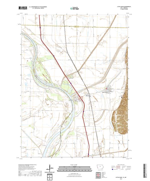
2022 Map of Little Sioux
USGS Topo · Published 2022About this map
The Missouri River forms a shifting boundary between Iowa and Nebraska in this survey, where the river's dynamic hydrology is visible through features like Little Sioux Bend and the Tekamah Ditch. The community of Little Sioux sits at the eastern edge of the floodplain, anchored by a grid of streets including Vine St and Locust St. The landscape is defined by its water management and agricultural grid, with the Little Sioux River and the Soldier River Cutoff draining the fertile lowlands. For genealogists and local historians, several burial sites are documented across the terrain, including Conyers Cem, Little Sioux Cem, and Ruffcorn Cem. Significant transportation corridors such as I-29 and the Larpenteur Memorial Rd provide context for modern movement through this historic river valley.
Find a feature on this map
81 named features on this map. Tap any name to fly to it.
Don’t see what you’re looking for? This feature index may not catch every label — zoom into the map to look around manually.
Map Details
Editions of this 2022 Little Sioux Map
This is the sole edition of this map. No revisions or reprints were ever made.
Other maps of this area

1954 · Omaha
USGS Topo · 1:250,000

1955 · Fremont
USGS Topo · 1:250,000

1957 · Fremont
USGS Topo · 1:250,000

1957 · Omaha
USGS Topo · 1:250,000

1958 · Omaha
USGS Topo · 1:250,000

1958 · Fremont
USGS Topo · 1:250,000

1970 · Little Sioux
USGS Topo · 1:24,000
1970 · Tekamah NW
USGS Topo · 1:24,000
1970 · Blencoe
USGS Topo · 1:24,000

1970 · Herman
USGS Topo · 1:24,000