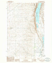
1986 Map of Little Soap Lake
USGS Topo · Published 1986About this map
The town of Soap Lake serves as a gateway to the dramatic geological formations of the Grand Coulee during the mid-1980s. This survey illustrates the sharp descent from the high plateau of the Douglas Co and Grant Co border into the Lower Grand Coulee. The hydrology of this arid landscape is marked by unique alkaline water bodies like Lake Lenore and Little Soap Lake, buffered by extensive conservation lands such as the Lake Lenore State Wildlife Management Area.
Find a feature on this map
26 named features on this map. Tap any name to fly to it.
Don’t see what you’re looking for? This feature index may not catch every label — zoom into the map to look around manually.
Map Details
Editions of this 1986 Little Soap Lake Map
This is the sole edition of this map. No revisions or reprints were ever made.
Other maps of this area

1953 · Ritzville
USGS Topo · 1:250,000

1956 · Ephrata
USGS Topo · 1:62,500

1956 · Ephrata
USGS Topo · 1:24,000

1956 · Ephrata SW
USGS Topo · 1:24,000

1956 · Grant Orchards
USGS Topo · 1:24,000

1956 · Soap Lake
USGS Topo · 1:24,000

1959 · Ritzville
USGS Topo · 1:250,000

1965 · Ritzville
USGS Topo · 1:250,000

1965 · Jameson Lake SW
USGS Topo · 1:24,000

1965 · Jameson Lake SE
USGS Topo · 1:24,000