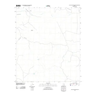
2010 Map of Little Star Mountain
USGS Topo · Published 2010About this map
Jeff Ranch serves as a primary point of human activity in this West Texas landscape, reached by the eponymous Jeff Ranch Rd. The terrain is defined by its drainage systems and high points, most notably Little Star Mountain and the deep incisions of Horse Thief Canyon and Lochousen Canyon. Water sources are critical in this arid environment, marked by localized features such as White Tanks, Indian Springs, and Adobe Springs. The map illustrates a network of draws and creeks, including Limpia Creek and South Carrizo Draw, which dictate the movement of both water and travel. For researchers and genealogists, these specific ranch names and water tank locations like Cavett Tank provide concrete data points for tracking property boundaries and land use in this part of Pecos County.
Find a feature on this map
13 named features on this map. Tap any name to fly to it.
Don’t see what you’re looking for? This feature index may not catch every label — zoom into the map to look around manually.
Map Details
Editions of this 2010 Little Star Mountain Map
This is the sole edition of this map. No revisions or reprints were ever made.
Other maps of this area

1894 · Fort Davis
USGS Topo · 1:125,000

1897 · Fort Davis
USGS Topo · 1:125,000

1929 · Hovey
USGS Topo · 1:125,000

1954 · Fort Stockton
USGS Topo · 1:250,000

1958 · Fort Stockton
USGS Topo · 1:250,000

1970 · Deep Well Ranch
USGS Topo · 1:24,000

1973 · Fort Stockton
USGS Topo · 1:250,000
1980 · Henderson Mesa
USGS Topo · 1:24,000
1980 · Barrilla Mountains East
USGS Topo · 1:24,000
1980 · Hovey SW
USGS Topo · 1:24,000