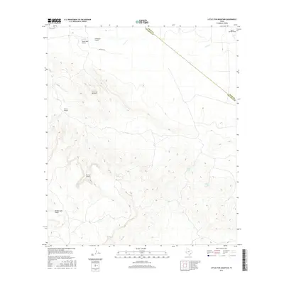
2016 Map of Little Star Mountain
USGS Topo · Published 2016About this map
Little Star Mountain rises above a landscape of deep drainages and cattle-ranching infrastructure along the boundary of Pecos and Jeff Davis counties. This territory is defined by its system of named canyons, including the evocatively titled Horse Thief Canyon and Lochousen Canyon in the north, as well as Rincon Canyon and Rooney Canyon to the southwest. Water management is central to the land's utility, evidenced by the scattered development of White Tanks, Cavett Tank, and the naturally occurring Indian Springs and Adobe Springs. Sparse transportation corridors like Limpia Creek Rd and Jeff Ranch Rd provide the only access through this dissected terrain. The drainage patterns of Limpia Cr and South Carrizo Draw illustrate the intermittent water flow characteristic of the region, where every canyon and draw serves as a vital conduit during the rare periods of rainfall.
Find a feature on this map
15 named features on this map. Tap any name to fly to it.
Don’t see what you’re looking for? This feature index may not catch every label — zoom into the map to look around manually.
Map Details
Editions of this 2016 Little Star Mountain Map
This is the sole edition of this map. No revisions or reprints were ever made.
Other maps of this area

1894 · Fort Davis
USGS Topo · 1:125,000

1897 · Fort Davis
USGS Topo · 1:125,000

1929 · Hovey
USGS Topo · 1:125,000

1954 · Fort Stockton
USGS Topo · 1:250,000

1958 · Fort Stockton
USGS Topo · 1:250,000

1970 · Deep Well Ranch
USGS Topo · 1:24,000

1973 · Fort Stockton
USGS Topo · 1:250,000
1980 · Henderson Mesa
USGS Topo · 1:24,000
1980 · Barrilla Mountains East
USGS Topo · 1:24,000
1980 · Hovey SW
USGS Topo · 1:24,000