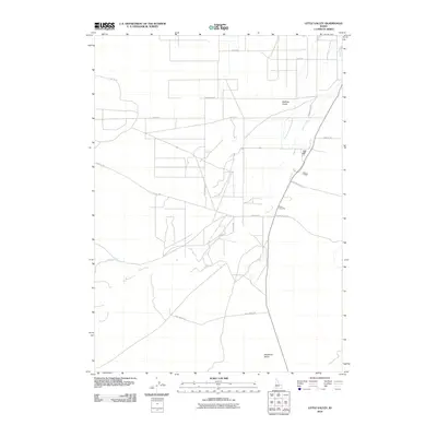
2010 Map of Little Valley
USGS Topo · Published 2010About this map
Stone Cemetery sits near the eastern edge of this Owyhee County landscape, where the high desert terrain is marked by deep drainages and irrigation efforts. The convergence of Big Jacks Creek and Little Jacks Creek defines the local hydrology, feeding into the primary channel of Jacks Creek as it flows north. Human activity in this arid environment is evidenced by a network of rural routes and significant water infrastructure like the Benham Canal. The naming of roads such as Mormon Blvd, Sho Fly Rd, and Sugar Valley Rd suggests the cultural and agricultural history of the region. Topographic features like Halfway Gulch and the isolated Deadman Gulch further illustrate the character of this southwestern Idaho cattle country.
Find a feature on this map
15 named features on this map. Tap any name to fly to it.
Don’t see what you’re looking for? This feature index may not catch every label — zoom into the map to look around manually.
Map Details
Editions of this 2010 Little Valley Map
This is the sole edition of this map. No revisions or reprints were ever made.
Other maps of this area

1946 · Mouth of Bruneau
USGS Topo · 1:24,000

1947 · Little Valley
USGS Topo · 1:24,000

1947 · Grand View
USGS Topo · 1:62,500

1947 · Bruneau
USGS Topo · 1:62,500

1947 · Grand View
USGS Topo · 1:24,000

1947 · Bruneau
USGS Topo · 1:24,000

1947 · Sugar Valley
USGS Topo · 1:24,000

1947 · Chalk Hills
USGS Topo · 1:24,000
1948 · Grand View
USGS Topo · 1:24,000
1948 · Little Valley
USGS Topo · 1:24,000