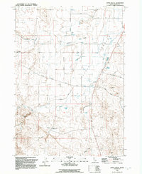
1992 Map of Little Valley
USGS Topo · Published 1992About this map
Little Valley is defined by its network of seasonal watercourses and grazing infrastructure in this 1990s Owyhee County study. The landscape is characterized by the convergence of Jacks Creek, Little Valley Creek, and the deep incisions of Halfway Gulch and Deadman Gulch. Evidence of the region’s agricultural and industrial utility is prominent, from the Halfway Cattle Drive to the Little Valley Compressor Station. Local history is anchored at the Stone Cemetery, while a system of named routes like Mormon Boulevard, Shofly Cutoff Road, and Tindall Road provides a view of how this high-desert terrain was navigated and utilized. A Radio Tower and various pumping stations underscore the modern infrastructure supporting this remote area at the close of the twentieth century.
Find a feature on this map
19 named features on this map. Tap any name to fly to it.
Don’t see what you’re looking for? This feature index may not catch every label — zoom into the map to look around manually.
Map Details
Editions of this 1992 Little Valley Map
This is the sole edition of this map. No revisions or reprints were ever made.
Other maps of this area

1946 · Mouth of Bruneau
USGS Topo · 1:24,000

1947 · Little Valley
USGS Topo · 1:24,000

1947 · Grand View
USGS Topo · 1:62,500

1947 · Bruneau
USGS Topo · 1:62,500

1947 · Grand View
USGS Topo · 1:24,000

1947 · Bruneau
USGS Topo · 1:24,000

1947 · Sugar Valley
USGS Topo · 1:24,000

1947 · Chalk Hills
USGS Topo · 1:24,000
1948 · Grand View
USGS Topo · 1:24,000
1948 · Little Valley
USGS Topo · 1:24,000