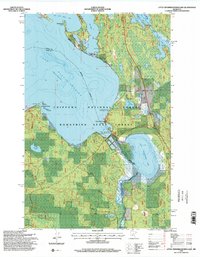
1996 Map of Little Winnibigoshish Lake
USGS Topo · Published 2000About this map
The Winnie Dam controls the passage where the Mississippi River flows between the sprawling waters of Lake Winnibigoshish and the smaller Little Winnibigoshish Lake. This northern Minnesota landscape, split between Itasca and Cass Counties, is a complex network of points and bays within the Chippewa National Forest. The settlement of Winnie and an adjacent cemetery sit near the river's exit from the main lake, providing a focal point for researchers interested in the local history of the dam's operation and the surrounding Bowstring State Forest. The map also records specialized land use, such as a fish hatchery and the West Banks No 2 Impoundment, alongside prominent features like Sugarbush Point and Battle Point that define the irregular shoreline of Mc Avity Bay.
Find a feature on this map
21 named features on this map. Tap any name to fly to it.
Don’t see what you’re looking for? This feature index may not catch every label — zoom into the map to look around manually.
Map Details
Editions of this 1996 Little Winnibigoshish Lake Map
2 editions found
Other maps of this area

1919 · Max
USGS Topo · 1:62,500

1954 · Bemidji
USGS Topo · 1:250,000

1954 · Hibbing
USGS Topo · 1:250,000

1957 · Bemidji
USGS Topo · 1:250,000

1957 · Hibbing
USGS Topo · 1:250,000

1958 · Bemidji
USGS Topo · 1:250,000

1958 · Hibbing
USGS Topo · 1:250,000

1964 · Hibbing
USGS Topo · 1:250,000

1970 · Bowstring Lake
USGS Topo · 1:24,000

1970 · Ball Club
USGS Topo · 1:24,000