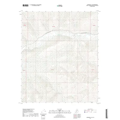
2017 Map of Livengood A-1 NE
USGS Topo · Published 2017About this map
The Chatanika River winds through the interior Alaskan wilderness north of Fairbanks, serving as the central drainage for a network of creeks and gold-bearing valleys. This 2017 survey shows the Steese Expressway/Highway as it cuts across the northern terrain, providing the primary modern corridor through this upland region. The landscape is defined by its complex hydrology, with numerous tributaries such as Kokomo Cr, Vadine Cr, and the colorfully named Rusty Gold Cr feeding into the main river system. These creek names often hint at the prospecting history of the Fairbanks North Star Borough. The map detail highlights the intersection of transportation and topography, tracing the high-country routes and the low-lying wetlands surrounding Crooked Cr and Boston Cr in the northern townships.
Find a feature on this map
20 named features on this map. Tap any name to fly to it.
Don’t see what you’re looking for? This feature index may not catch every label — zoom into the map to look around manually.
Map Details
Editions of this 2017 Livengood A-1 NE Map
This is the sole edition of this map. No revisions or reprints were ever made.
Other maps of this area

1945 · Livengood
USGS Topo · 1:250,000

1951 · Livengood
USGS Topo · 1:250,000

1951 · Circle
USGS Topo · 1:250,000

1952 · Livengood A-1
USGS Topo · 1:63,360

1954 · Circle A-6
USGS Topo · 1:63,360

1954 · Circle B-6
USGS Topo · 1:63,360

1954 · Livengood B-1
USGS Topo · 1:63,360
1954 · Livengood A-1
USGS Topo · 1:63,360

1955 · Circle
USGS Topo · 1:250,000

1956 · Livengood
USGS Topo · 1:250,000