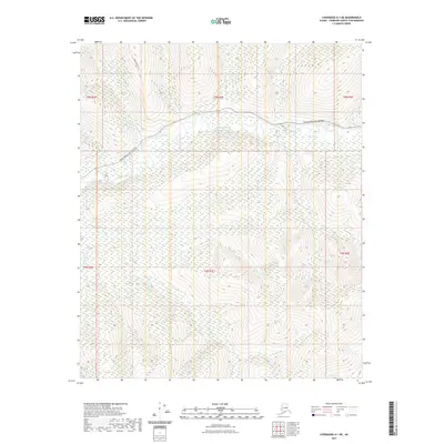
2021 Map of Livengood A-1 NE
USGS Topo · Published 2021About this map
The Chatanika River dominates this interior Alaska landscape north of Fairbanks, winding through a wide valley in the northern portion of the quadrangle. Access to the region is defined by the Steese Expressway/Highway, which runs parallel to the river's course, providing a modern transportation corridor through the Fairbanks North Star Borough. The terrain is characterized by a dense network of creek drainages, including Kokomo Cr, Juniper Cr, and the appropriately named Rusty Gold Cr, reflecting the region's long association with placer mining and exploration.
Find a feature on this map
18 named features on this map. Tap any name to fly to it.
Don’t see what you’re looking for? This feature index may not catch every label — zoom into the map to look around manually.
Map Details
Editions of this 2021 Livengood A-1 NE Map
This is the sole edition of this map. No revisions or reprints were ever made.
Other maps of this area

1945 · Livengood
USGS Topo · 1:250,000

1951 · Livengood
USGS Topo · 1:250,000

1951 · Circle
USGS Topo · 1:250,000

1952 · Livengood A-1
USGS Topo · 1:63,360

1954 · Circle A-6
USGS Topo · 1:63,360

1954 · Circle B-6
USGS Topo · 1:63,360

1954 · Livengood B-1
USGS Topo · 1:63,360
1954 · Livengood A-1
USGS Topo · 1:63,360

1955 · Circle
USGS Topo · 1:250,000

1956 · Livengood
USGS Topo · 1:250,000