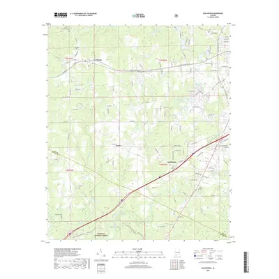
2018 Map of Loachapoka
USGS Topo · Published 2018About this map
Loachapoka and the western edge of Auburn anchor this 2018 survey, reflecting a landscape where university-town expansion meets quiet rural Lee County traditions. The area is defined by a dense network of water features and community landmarks, ranging from Vaughans Mill Pond in the south to Plainsman Lake in the north. Numerous family and community cemeteries are scattered across the terrain, including Loachapoka Cem, Armstrong Cem, and Pine Knot Cem, providing essential points of interest for genealogists tracing local lineage. The southern portion of the sheet transitions into the protected acreage of the Tuskegee National Forest, where the terrain is crossed by numerous unpaved forest roads and creeks like Choctafaula Cr. The map captures the meeting of older settlements like Beehive with contemporary infrastructure, showing the continued evolution of this central Alabama region.
Find a feature on this map
132 named features on this map. Tap any name to fly to it.
Don’t see what you’re looking for? This feature index may not catch every label — zoom into the map to look around manually.
Map Details
Editions of this 2018 Loachapoka Map
This is the sole edition of this map. No revisions or reprints were ever made.
Other maps of this area

1906 · Dadeville
USGS Topo · 1:125,000

1907 · Opelika
USGS Topo · 1:125,000

1909 · Opelika
USGS Topo · 1:125,000

1955 · Phenix City
USGS Topo · 1:250,000

1957 · Phenix City
USGS Topo · 1:250,000

1958 · Phenix City
USGS Topo · 1:250,000

1971 · Waverly
USGS Topo · 1:24,000

1971 · Little Texas
USGS Topo · 1:24,000
1971 · Opelika West
USGS Topo · 1:24,000

1971 · Loachapoka
USGS Topo · 1:24,000