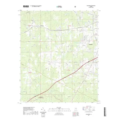
2021 Map of Loachapoka
USGS Topo · Published 2021About this map
Loachapoka and the western outskirts of Auburn are the primary settlements in this region at the edge of the Tuskegee National Forest. The landscape is defined by the headwaters of Choctafaula Cr and Hodnett Cr, which flow through a rolling terrain marked by numerous small private ponds and reservoirs such as Plainsman Lake and Richards Pond. For genealogists, the map is particularly detailed regarding burial sites, noting several family and community landmarks including the Lewis Allen Foster Family Cem, Pine Knot Cem, and Armstrong Cem. The presence of Vaughans Mill-Pond near the forest boundary suggests the area's long-standing reliance on local water resources, while the small community of Beehive sits centrally along the network of county roads that connect these rural Lee and Macon County homesteads.
Find a feature on this map
133 named features on this map. Tap any name to fly to it.
Don’t see what you’re looking for? This feature index may not catch every label — zoom into the map to look around manually.
Map Details
Editions of this 2021 Loachapoka Map
This is the sole edition of this map. No revisions or reprints were ever made.
Other maps of this area

1906 · Dadeville
USGS Topo · 1:125,000

1907 · Opelika
USGS Topo · 1:125,000

1909 · Opelika
USGS Topo · 1:125,000

1955 · Phenix City
USGS Topo · 1:250,000

1957 · Phenix City
USGS Topo · 1:250,000

1958 · Phenix City
USGS Topo · 1:250,000

1971 · Waverly
USGS Topo · 1:24,000

1971 · Little Texas
USGS Topo · 1:24,000
1971 · Opelika West
USGS Topo · 1:24,000

1971 · Loachapoka
USGS Topo · 1:24,000