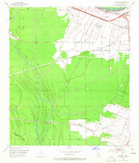
1953 Map of Lobdell
USGS Topo · Published 1965About this map
The agricultural and industrial landscape of West Baton Rouge Parish is defined here by a dense network of plantation-era settlements and rail infrastructure. Settlements like Lobdell, Westover, and Allendale follow the corridor of the Missouri Pacific and Texas and Pacific railroads, reflecting a local economy tied to the movement of goods across the Louisiana delta. The map reveals a deeply etched drainage system where the Grand Bayou and Little Choctaw Bayou navigate a terrain marked by extensive spoil banks, indicative of large-scale water management and land modification efforts near the Mississippi River.
Find a feature on this map
34 named features on this map. Tap any name to fly to it.
Don’t see what you’re looking for? This feature index may not catch every label — zoom into the map to look around manually.
Map Details
Editions of this 1953 Lobdell Map
5 editions found
Other maps of this area

1906 · Bayou Sara
USGS Topo · 1:125,000

1908 · Baton Rouge
USGS Topo · 1:62,500

1939 · Zachary
USGS Topo · 1:62,500

1939 · Baton Rouge
USGS Topo · 1:62,500

1940 · Grosse Tete
USGS Topo · 1:62,500

1953 · Baton Rouge West
USGS Topo · 1:24,000

1953 · Plaquemine
USGS Topo · 1:24,000

1953 · Lobdell
USGS Topo · 1:24,000

1953 · Addis
USGS Topo · 1:24,000

1953 · Grosse Tete SW
USGS Topo · 1:24,000