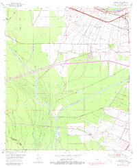
1953 Map of Lobdell
USGS Topo · Published 1980About this map
Sugar cane fields and industrial expansion meet the swampy lowlands of West Baton Rouge Parish in this mid-century landscape. The Texas and Pacific railroad serves as a primary transit corridor, linking settlements like Lobdell, Westover, and Brusly along the eastern edge. Industrial activity is evident in the Port Allen Oil Field and the massive dredging of the Intracoastal Waterway (Port Allen Canal), which cuts through the bottomland forests. Local genealogy is anchored by sites such as Christ Ch Cem and Brown Ch, while the western portion of the map is dominated by the intricate drainage of Grand Bayou and Choctaw Bayou. This era captures the parish during a period of infrastructure modernization, where modern radio towers and 4-lane highways began to intersect with long-established bayou communities like Lejeune and Ithra.
Find a feature on this map
34 named features on this map. Tap any name to fly to it.
Don’t see what you’re looking for? This feature index may not catch every label — zoom into the map to look around manually.
Map Details
Editions of this 1953 Lobdell Map
5 editions found
Other maps of this area

1906 · Bayou Sara
USGS Topo · 1:125,000

1908 · Baton Rouge
USGS Topo · 1:62,500

1939 · Zachary
USGS Topo · 1:62,500

1939 · Baton Rouge
USGS Topo · 1:62,500

1940 · Grosse Tete
USGS Topo · 1:62,500

1953 · Baton Rouge West
USGS Topo · 1:24,000

1953 · Plaquemine
USGS Topo · 1:24,000

1953 · Lobdell
USGS Topo · 1:24,000

1953 · Addis
USGS Topo · 1:24,000

1953 · Grosse Tete SW
USGS Topo · 1:24,000