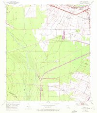
1953 Map of Lobdell
USGS Topo · Published 1972About this map
The Intracoastal Waterway (Port Allen Canal) cuts a straight path through this West Baton Rouge Parish landscape, reflecting the heavy industrial and maritime engineering of the mid-20th century. The area is defined by its complex bayou systems, including Little Choctaw Bayou, Alligator Bayou, and Whisky Bayou, which weave around extensive spoil banks. These man-made features highlight the scale of dredging operations required to maintain the region's vital water transport routes.
Find a feature on this map
38 named features on this map. Tap any name to fly to it.
Don’t see what you’re looking for? This feature index may not catch every label — zoom into the map to look around manually.
Map Details
Editions of this 1953 Lobdell Map
5 editions found
Other maps of this area

1906 · Bayou Sara
USGS Topo · 1:125,000

1908 · Baton Rouge
USGS Topo · 1:62,500

1939 · Zachary
USGS Topo · 1:62,500

1939 · Baton Rouge
USGS Topo · 1:62,500

1940 · Grosse Tete
USGS Topo · 1:62,500

1953 · Baton Rouge West
USGS Topo · 1:24,000

1953 · Plaquemine
USGS Topo · 1:24,000

1953 · Lobdell
USGS Topo · 1:24,000

1953 · Addis
USGS Topo · 1:24,000

1953 · Grosse Tete SW
USGS Topo · 1:24,000