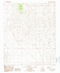
1990 Map of Lobo Hill SE
USGS Topo · Published 1990About this map
Dean Ranch anchors the western edge of this Torrance County landscape, a region defined by the complex drainage patterns of Red Canyon Draw and McGillivray Draw. Published in 1990 as a provisional map, the survey reveals a high-desert environment where water management is paramount for ranching and industry. Isolated infrastructure such as the Allan Well, Angus Well, and West Douglas Well dot the terrain, alongside numerous Water Tanks that sustained the local livestock economy.
Find a feature on this map
13 named features on this map. Tap any name to fly to it.
Don’t see what you’re looking for? This feature index may not catch every label — zoom into the map to look around manually.
Map Details
Editions of this 1990 Lobo Hill SE Map
This is the sole edition of this map. No revisions or reprints were ever made.
Other maps of this area

1954 · Fort Sumner
USGS Topo · 1:250,000

1958 · Fort Sumner
USGS Topo · 1:250,000

1960 · Lobo Hill
USGS Topo · 1:62,500

1978 · Laguna Del Perro North
USGS Topo · 1:24,000

1978 · Pedernal Mountain
USGS Topo · 1:24,000

1978 · Pedernal
USGS Topo · 1:24,000
1978 · Rock Lake
USGS Topo · 1:24,000

1978 · Lucy
USGS Topo · 1:24,000
1984 · Vaughn
USGS Topo · 1:100,000
1990 · Lobo Hill
USGS Topo · 1:24,000