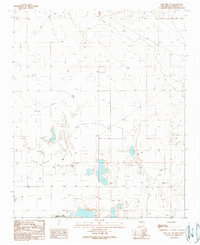
1990 Map of Lobo Hill SW
USGS Topo · Published 1990About this map
Laguna del Perro and the surrounding alkaline flats define this part of Torrance County, where water management is the primary marker of human presence. The landscape is characterized by a network of drainage features like Salt Draw and Big Draw, alongside an extensive system of man-made infrastructure. Numerous named water sources, including the Sprule Windmill, Piedroso Windmill, and Childress Well, suggest a dispersed ranching economy reliant on tapped groundwater. An Aqueduct and Pipeline further indicate the logistical efforts to move water across this arid terrain. Near the center of the map, the elevation of Lobo Hill rises above the basin, while localized industrial activity is noted at a Gravel Pit. The map reflects a late-20th-century update of a landscape that has remained largely defined by its hydrology and isolated landmarks since the mid-century surveys.
Find a feature on this map
23 named features on this map. Tap any name to fly to it.
Don’t see what you’re looking for? This feature index may not catch every label — zoom into the map to look around manually.
Map Details
Editions of this 1990 Lobo Hill SW Map
This is the sole edition of this map. No revisions or reprints were ever made.
Other maps of this area

1917 · Estancia
USGS Topo · 1:125,000

1954 · Fort Sumner
USGS Topo · 1:250,000

1954 · Socorro
USGS Topo · 1:250,000

1956 · Estancia
USGS Topo · 1:62,500

1956 · Mountainair
USGS Topo · 1:62,500

1958 · Socorro
USGS Topo · 1:250,000

1958 · Fort Sumner
USGS Topo · 1:250,000

1960 · Lobo Hill
USGS Topo · 1:62,500

1962 · Socorro
USGS Topo · 1:250,000

1978 · Laguna Del Perro North
USGS Topo · 1:24,000