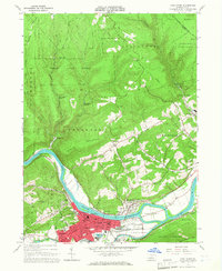
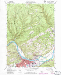
1965 Map of Lock Haven
USGS Topo · Published 1967About this map
Lock Haven State College anchors the riverfront in this mid-1960s study of the West Branch Susquehanna River valley. The urban center of Lock Haven is highly detailed, showing the layout of Church St, the Lock Haven Municipal Airport, and several parochial institutions including Immaculate Conception Sch and St Agnes Sch. The landscape is defined by the heavy infrastructure of a previous era, including the path of the Pennsylvania Canal and the NYC Aqueduct, which parallel the Pennsylvania and New York Central railroad lines. Outside the city, the terrain rises sharply toward Woodward Mountain and Bald Eagle Mtn, where vast tracts of the Sproul State Forest and Tiadaghton State Forest begin. Notable local landmarks like the Radio Tower (WBPZ) and the Swissdale Cem provide specific points of interest for genealogists and local historians.
Find a feature on this map
83 named features on this map. Tap any name to fly to it.
Don’t see what you’re looking for? This feature index may not catch every label — zoom into the map to look around manually.
Map Details
Editions of this 1965 Lock Haven Map
5 editions found
Other maps of this area

1921 · Howard
USGS Topo · 1:48,000

1921 · Lock Haven
USGS Topo · 1:62,500

1923 · Howard
USGS Topo · 1:62,500

1923 · Lock Haven
USGS Topo · 1:62,500

1935 · Waterville
USGS Topo · 1:24,000

1937 · Waterville
USGS Topo · 1:48,000

1943 · Hyner
USGS Topo · 1:62,500

1943 · Waterville
USGS Topo · 1:62,500

1944 · Lock Haven
USGS Topo · 1:62,500

1946 · Renovo East
USGS Topo · 1:62,500