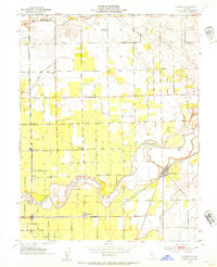
1953 Map of Lockeford
USGS Topo · Published 1954About this map
The Mokelumne River winds through this Central Valley landscape, defining the agricultural and settlement patterns of northern San Joaquin County. During the early 1950s, the community of Lockeford served as a focal point along the Southern Pacific rail line, accompanied by local landmarks like the Locke Cem and a nearby Gaging Sta. To the west, the Central California Traction railroad cuts a straight north-south line through smaller settlements such as Kenefick, Youngstown, and Roma. The area's commitment to local education and community is evident in the placement of the Oak View Union Sch and Bruella Sch. An intricate network of rural roads, including Jahant Road and Peltier Road, connects numerous farmsteads and specialized sites like the Winery near Victor, illustrating the region's post-war viticulture and farming expansion.
Find a feature on this map
35 named features on this map. Tap any name to fly to it.
Don’t see what you’re looking for? This feature index may not catch every label — zoom into the map to look around manually.
Map Details
Editions of this 1953 Lockeford Map
2 editions found
Other maps of this area

1894 · Lodi
USGS Topo · 1:125,000

1908 · Waterloo
USGS Topo · 1:31,680

1908 · Linden
USGS Topo · 1:31,680

1908 · Lockeford
USGS Topo · 1:31,680

1909 · Clay
USGS Topo · 1:31,680

1909 · Goose Creek
USGS Topo · 1:31,680

1909 · Clements
USGS Topo · 1:31,680

1910 · Castle
USGS Topo · 1:31,680

1910 · Woodbridge
USGS Topo · 1:31,680

1910 · Galt
USGS Topo · 1:31,680